Art Gene: Mapping Morecambe Bay
Date uploaded: January 22, 2014
Art Gene’s artist/founder directors, Stuart Bastik and Maddi Nicholson, launched the Morecambe Bay Design Café project - 'Mapping the Bay' - in December. The mapping process forges links with communities and facilitates the development of a deep understanding of places and the people who live them. This is re-presented through artist-designed maps but also forms the basis of research that underpins Art Gene's design methodology associated with planned future infrastructure and interpretation projects.
The project has been developed in partnership with Morecambe Bay Partnership and is being delivered through new partnerships with RSPB, Nurture Lakeland and Bay Tourism.
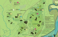
Stuart Bastik created a series of four draft maps to begin the consultation process. During 7 consultation events we gathered over 1200 additional pieces of information which Stuart is now adding to the artwork before a second phase of events begins with the updated draft maps.
This is the start of an ambitious five year project (four years in development) which begins with a programme of research and public consultation. The aim is to uncover the highlights & little known natural, industrial and cultural heritage assets of the bay alongside current points of interest. These can be discovered by the walker, cyclist and armchair traveller by following a series of new walking and cycling routes.
'Our aim is to map the complexity and contradictions of places as a means through which we may come closer to the reality of what places are in order that we can facilitate a full and frank discussion about how best to improve them sustainably.' Stuart Bastik
The maps span the Cumbria & Lancashire coasts of Morecambe Bay: Furness Peninsula, Cartmel Peninsula, Arnside/Silverdale and Morecambe/Heysham areas.
The new maps build on recent work with Barrow Borough Council which developed a map for the Islands of Barrow (now on sale-see below).This map was part of a wider project to create a people's museum on Piel Island which explores the diverse points of interest, history and mythology of the Islands - the notion being that - 'places are never one thing but layers of things through time and in any particular moment... understanding this complexity is essential if we are to build sustainable communities & infrastructure' Stuart Bastik.
Art Gene will continue to work with residents, organisations, businesses, local authorities and community groups to help uncover Morecambe Bay through the eyes of local people and represent their knowledge and passion for this unique area in four new 'Seldom Seen' maps and planned mobile phone apps.
More events are planned for 2014.